FAQs & Guides

Your Questions Answered

Surveying and town planning can be complex and, for many, unfamiliar territory.

We are here to answer your questions about what it is we do, how we can help realise your development goals or resolve issues, and some of the common technicalities in our fields of expertise.

Below are the answers to some of our most frequently asked questions. Make sure to also check out out our guides to learn more about particular planning and surveying topics.

Town Planning

Subdivision costs can vary depending on extent of civil works needed and Council requirements. The total cost of a basic subdivision (1 into 2 lots) in Brisbane is typically in the range of $75-120k:

1. Development Application: $8-15k

  • Contour and detail survey
  • Subdivision proposal plan
  • Engineering reports/plans (if required)
  • State Government referral (if required)
  • Public notification (if required)
  • Planning fees (reports and lodgement)
  • Council application fees


2.Development Costs: $60-100k

  • House demolition/site clearing
  • Site pegging/Survey Plan
  • Further engineering approvals (if required)
  • Earthworks (if required)
  • Stormwater infrastructure
  • Sewer and water connections
  • Electrical and telecommunications connections
  • Streetscape works (e.g. footpath, street trees—if required)
  • Remove/construct driveway crossovers
  • Infrastructure charges


3.Plan Sealing and Titles: $8-10k

  • Planning fees (compliance report and plan sealing application)
  • Council application fees
  • Title registration fees

The biggest cost variables for small-scale subdivisions are usually servicing and earthworks. That is, whether mains need to be extended, significant filling is necessary, or underground electricity is required.

In almost all cases, subdivision in Queensland requires development approval (DA) from Council. For sites within a designated Priority Development Area (PDA), assessment may instead be undertaken by the State government.

Rooming accommodation is a defined land use under the Planning Regulation 2017. It involves a residential premises that may be rented to multiple separate parties on a room-by-room basis and which includes common facilities for occupants. Importantly, bedrooms in rooming accommodation cannot be ‘self-contained’ (i.e. with a kitchen and bathroom) or they may be provided with ‘limited facilities’. Each Council has its own interpretation of what constitutes ‘limited facilities’ as it is not defined in the Regulation. Advice should always be sought from Council or a planner for guidance on complying with current policies. Failure to comply can result in enforcement action from Council. Planning Regulation 2017, Schedule 24:

Rooming accommodation means the use of premises for—
  1. residential accommodation, if each resident—
    1. has a right to occupy 1 or more rooms on the premises; and
    2. does not have a right to occupy the whole of the premises; and
    3. does not occupy a self-contained unit, as defined under the Residential Tenancies and Rooming Accommodation Act 2008, schedule 2, or has only limited facilities available for private use; and
    4. shares other rooms, facilities, furniture or equipment outside of the resident’s room with 1 or more other residents, whether or not the rooms, facilities, furniture or equipment are on the same or different premises; or
  2. a manager’s residence, an office or providing food or other service to residents, if the use is ancillary to the use in paragraph (a).
Examples of rooming accommodation—boarding house, hotel, monastery, off-site student accommodation.

Public notification is a requirement for applications subject to impact assessment. Typically, impact assessment is triggered where proposed lot sizes or land uses are inconsistent with Council’s assumptions for a zone or local plan area. Requirements for public notification are prescribed in the Planning Act 2016 and include:

  • Written notification (letters) to adjoining property owners
  • Advertisement in a locally circulating or online newspaper
  • Signage at each property frontage with details of the proposal

The above must be carried out during the public notification period which, for most applications, is 15 business days. This occurs after lodgement to Council as part of the development assessment process. Anyone who makes a submission during the public notification period in the correct form (a ‘properly made submission’) may appeal Council’s decision in the Planning and Environment Court.
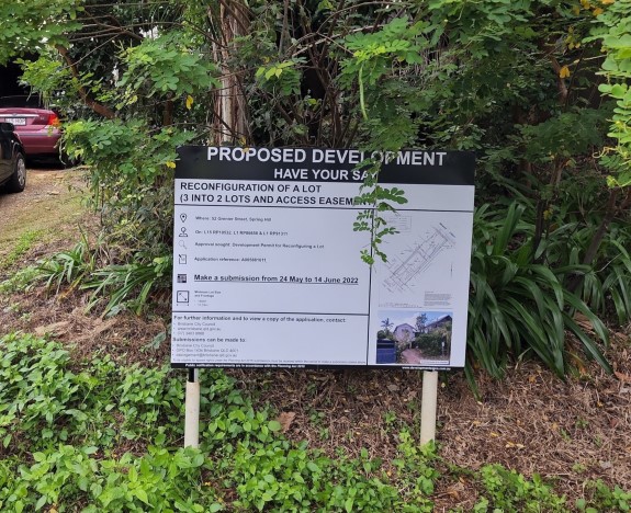
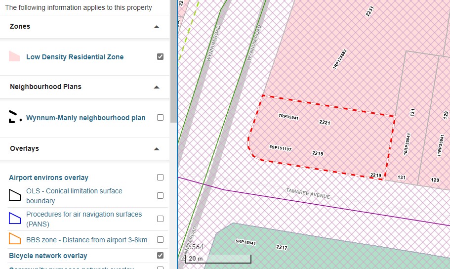
Most Councils in Queensland provide easy-to-use and publicly accessible online resources for determining the planning parameters of a site such as lot details, zoning, overlays, and applicable local plans. Some also include useful imagery, surface contours, services, and measuring/annotation tools.

Assessment time for a development application depends on the type of application, level of assessment, and complexity. Council’s workload also has an impact on processing time. Code assessment Most code assessable applications must be decided by Council within 45 business days of lodgement and payment of application fees. If an information request is issued by Council, assessment timeframes stop until a response is submitted—this can extend assessment timeframes. Impact assessment Impact assessable applications have an assessment period of 2-3 months. Complex applications routinely exceed this timeframe. RiskSMART RiskSMART or fast-track assessment is offered by some Councils and, for eligible applications, can reduce assessment timeframes to 2 weeks or less.

All new houses and most extensions require building approval from a private certifier. Only in particular circumstances will a new house or extensions/alterations also trigger a development application (DA) to Council. Some common triggers include:

  • Non-compliance with setbacks, building height or other siting requirements in the planning scheme
  • Heritage/character overlays
  • Ecological/environmental overlays

We frequently lodge development applications for houses and can easily check if what you are proposing will require a DA. Sometimes, minor alterations can be made to a proposal to avoid triggering assessment, saving time and money.

Some development applications require referral to a third party as part of the assessment process. The most common referrals are to the Queensland Government through the State Assessment and Referral Agency (SARA). Some triggers for State referral include:

  • Proximity to a State-controlled road or intersection
  • Proximity to a railway or busway corridor
  • Development outside the ‘Urban Footprint’ in South-East Queensland
  • Major development outside the Brisbane CBD
  • Development affected by State environmental overlays
  • Queensland Heritage Places

Common referrals to other entities include:

  • Properties affected by easements for oil or gas pipelines
  • Properties affected by electricity easements
  • Proximity to an electrical substation

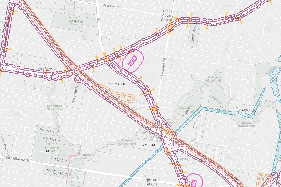
Application referrals can be identified using the Queensland Government’s Development Assessment Mapping System (DAMS). A referral agency response may include conditions of approval or, sometimes, no requirements. The State Government can direct Council to refuse an application if there are major issues that cannot be resolved, though this is very rare. Referrals run concurrently with Council’s assessment. However, if an information request is issued by a referral agency, overall assessment timeframes may be affected.

Most Councils offer a pre-lodgement meeting service, providing the opportunity for a confidential discussion with Council planners and specialists about a development proposal prior to preparing or lodging a development application (DA). Pre-lodgement meetings are valuable in a number of scenarios: Due diligence Purchasing property for prospective development can involve some degree of risk, particularly if the site is subject to notable planning constraints or a proposal is non-compliant with assessment benchmarks or just generally ‘out of the box’. In these instances, we often recommend a pre-lodgement meeting during a due diligence period. Assessing feasibility Pre-lodgement meetings can be useful for clarifying requirements such as earthworks, roadworks, and land dedication that can have a big impact on development cost or the end product. This can be critical for assessing the feasibility of a proposed development. Reducing outlays Development applications (DA) can be expensive. For high-risk proposals, it may be prudent to have a pre-lodgement meeting before investing thousands of dollars more in a DA that could be refused. The cost of a pre-lodgement meeting is usually significantly less than a DA. Each Council offers different pre-lodgement services and meeting types; some charge a fee and others are free of charge. If we are involved in the pre-lodgement meeting process, we will make sure all the necessary questions are asked and that the advice received from Council is easy to understand and process in the context of your development goals.

Surveying

An identification survey (also known as an ‘ident’ or boundary survey) involves marking the boundaries of an existing lot with pegs or other marks (nails, screws, etc. as appropriate). 
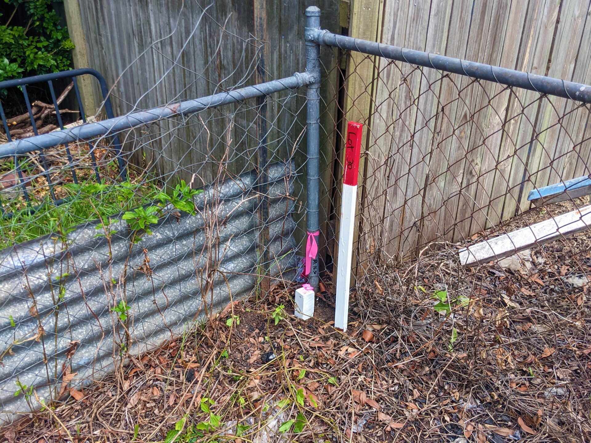
Identification surveys are often required for boundary fencing or to check for encroachments. They may also be undertaken prior to detailed design for a development to confirm site area and dimensions (particularly for older lots) or before construction where work is proposed near or on a boundary. When surveyors carry out an identification survey, they are required to prepare a plan for lodgement to the Department of Resources, showing the marks placed, the lot boundaries, and any encroachments identified.

A contour and detail survey is usually the first type of survey carried out for any development. It involves a survey of the existing contours of a site and location of features such as trees, structures, and visible services. The plan and data produced from a contour and detail survey is critical for architectural and civil design. A contour survey may also be required at the completion of a development (e.g. subdivision) to confirm that earthworks have been completed in accordance with a development approval.

Setout certificates from a surveyor are often requested by building certifiers before issuing their inspection certificates—particularly on urban lots wher

e setbacks are relevant to the building approval and the margin for error may be minimal. Where a setout certificate is required, it is imperative this survey is done before construction to avoid unpleasant (and potentially very expensive) surprises.

When an encroachment is revealed in an identification survey or subdivision survey, we are obliged under the Survey and Mapping Infrastructure Act 2003 to notify affected parties. Whether any action is taken with respect to encroachment is up to the landowners to decide. The most common solutions involve:

  1. Removing the structure or part of the structure encroaching.
  2. Leaving the structure as is and registering an encroachment easement.
  3. Realigning the boundary and transferring the affected land.

Often, for minor encroachments, no action is taken by either landowner. However, if you are having issues resolving an encroachment with your neighbour, you should seek independent legal advice. If required, we can assist with encroachment easements and boundary realignments.

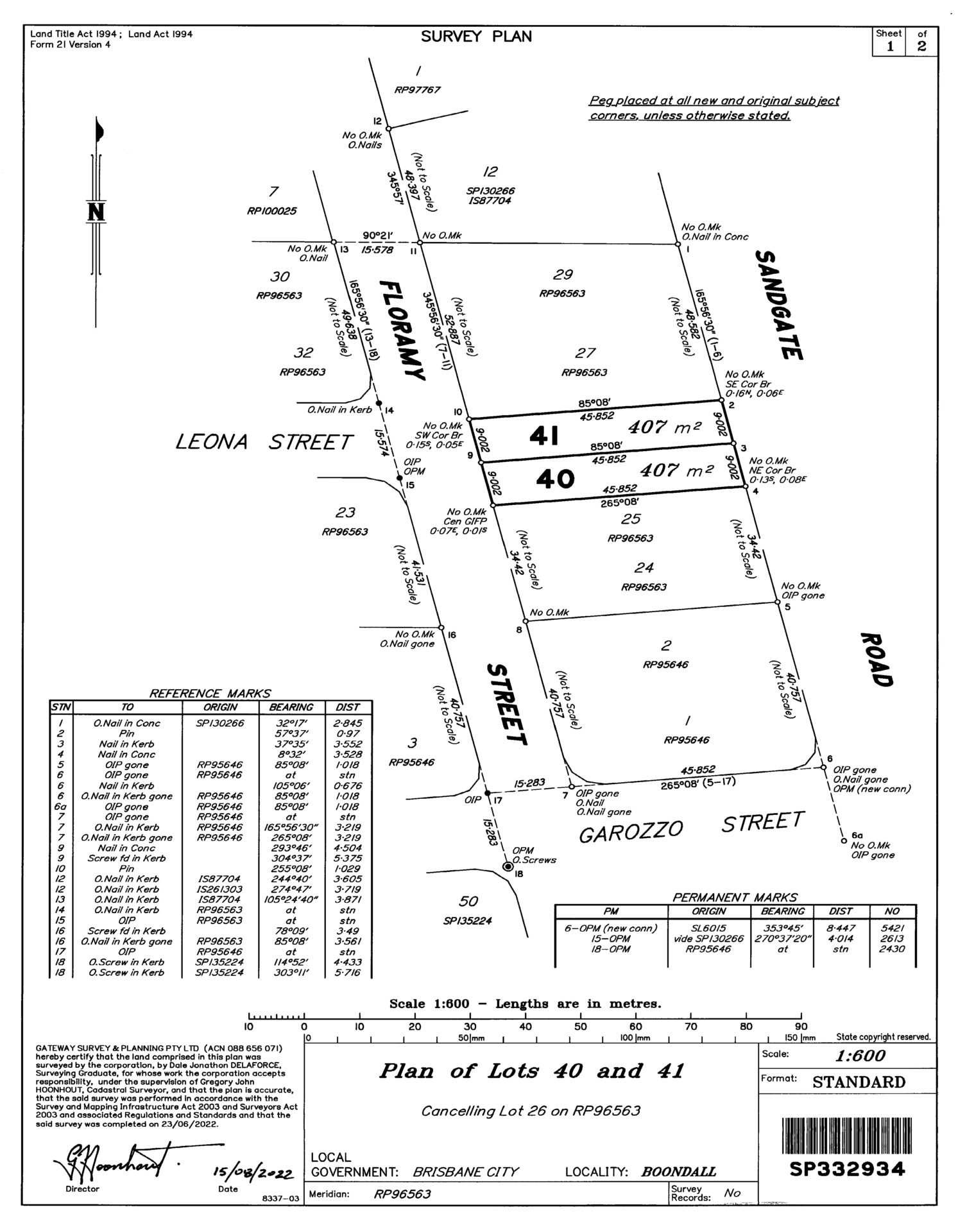
The Survey Plan is the official record of a lot’s dimensions and area according to the title. Survey Plans can be purchased from Titles Queensland. Lots should never be measured from digital mapping systems or the fences on site. Many older lots across Brisbane have standard sizes, as follows:

  • 405 m² (16 perches): 10.058 × 40.234 m
  • 607 m² (24 perches): 15.088 × 40.234 m
  • 809m² (32 perches): 20.117 × 40.234 m

Commercial leases are often required to be registered with Titles Queensland and recorded as an interest on the land title. Examples of leases requiring registration are those exceeding a 3-year term or part of a retail complex of 5 or more tenancies. A solicitor can advise whether a lease needs to be registered based on the specific circumstances. For a lease to be accepted by the Titles Registry, it usually needs to be accompanied by a suitably prepared sketch or plan of survey accurately describing the subject area of the building or land. Our surveyors have extensive experience preparing lease plans for retail, industrial, and other commercial buildings. We have also prepared new and amended lease plans for sporting groups in Council parks.

More

There are a few ways in which trees may be protected by Council or State government:

    • Local laws Most Councils have local laws that protect trees of certain attributes or through specific vegetation protection orders (VPOs). Redland City Council even includes a provision in its local law that protects all trees on any site with development potential, even before lodging a DA!


    • Planning scheme overlays Overlays may protect particular vegetation, such as native/waterway vegetation (environmental overlays) or significant trees (landscape or heritage overlays).


    • State overlays Like Council, the State government also designates vegetation protection under overlays, which can be viewed in the Development Assessment Mapping System (DAMS). Vegetation protected by the State is predominantly for environmental purposes.


  • Through a development application or approval Most planning schemes allow Council to nominate trees for retention and protection as part of a development approval, even if they were not formally protected prior to the application.

Tree protection can be a minefield, so it is always best to check with Council or a qualified arborist to confirm if approvals are required before removing trees.

Yes! Some residential and commercial buildings are occupied for years for rental before the owner decides to sell off units separately. The plan sealing process required to obtain ‘strata’ titling can be carried out at any time. We have even completed plan sealing for units over 40 years old!

Obtaining DA and plan sealing approval for a subdivision is not the end of the process. The final step is to register the plan of subdivision (Survey Plan) with the titles office to obtain a separate title for each lot. Only then are the new lots officially created and able to be sold or transferred. As we are registered for electronic lodgement with Titles Queensland, we can complete this process immediately after plan sealing for the quickest possible turnaround.

Council allocates street numbers for newly created lots after plan sealing. Addresses are then registered with the State government before being reflected across relevant systems such as Australia Post and NBN. For development on existing streets, new addresses may include an alpha suffix (e.g. 44A Example Street) if sufficient unallocated numbers are not available. Corner lots generally have a primary and secondary address. For vacant lots, Council will generally make an assumption on the primary address and provide the opportunity to request a change. Lots on a private road (Community Title Scheme) will be given sub-addresses similar to units (e.g. 1/44 Example Street).

The location and specifications of existing services like sewerage, water, and stormwater can have a big impact on the development potential of a site, building envelopes, and construction costs. There are a number of online resources available to find the location of services: Before You Dig Probably the most well-known source of underground services information, Before You Dig (formerly Dial Before You Dig) produces mapping from most infrastructure providers within a selected area. Maps in PDF format are emailed from each provider over the span of a few hours—not the most convenient process, but the service is free and covers a broad range of infrastructure. Interactive utilities maps Some utility providers offer online interactive mapping systems which can be quicker and more informative than the static maps provided by Before You Dig—

  • Urban Utilities (sewer and water in Brisbane, Ipswich, Scenic Rim, Lockyer Valley, and Somerset Region)
  • Unity Water (sewer and water in Moreton Bay Region, Sunshine Coast, and Noosa)
  • Energex/Ergon (electricity)

Council mapping Some Councils also maintain interactive mapping systems for stormwater and other utilities—

Guides

Still have Questions?

Please do not hesitate to contact our expert team of surveyors and town planners to see if we can assist!